Polygon Parts Service 🧩
General
Understanding Polygon Parts on Layer (records) management - Updates
This system utilizes polygons and layers to represent the precise area of a product and track all updates received over time. Polygons define the exact boundaries, while layers provide a structured way to integrate these updates. Let's delve deeper into how this system functions.
Polygons
Represent the precise area of a product and all its subsequent updates. Contain additional metadata like update date, accuracy, and photo sensor information.
Layers
Composed of continuous geographic regions defined by several polygons. Each polygon holds its own metadata. Updates are merged with overlapping layers below. Polygons within existing layers that overlap the new update (completely or partially) are re-calculated.
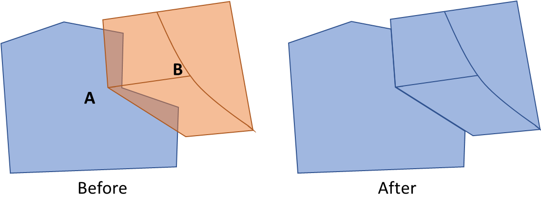
B is a new layer containing 3 polygon parts about to be merged into an existing layer. As you can see in the “After” figure on the right, the new layer parts contains the merged polygon parts of A and B. Each part hold its own metadata and related attributes PolygonParts attributes
WFS implementation
Raster polygon parts service uses the WFS protocol which is a READ-ONLY Web Feature Service.
it provides facilities for searching and retrieving feature data with the GetCapabilities, DescribeFeatureType and GetFeature operations all other operations are invalid.
For the full capabilities provided by the service see GetCapabilities
WFS partitions the queryable data into feature types each feature type has its own attributes describing the structure of the data itself. For the description of a feature type see DescribeFeatureType
Finally, Features can be retrieved with the GetFeature operation. the request returns a collection of geographic feature instances filtered according to a criteria set by the requesting client.
In polygon parts, each feature represents a single polygon
Authentication must be integrated in order to communicate with Map and Catalog services.
See the principles here
Overview
WFS protocol partitions the queryable features into different feature types. Each feature types actually represent other catalog layer Raster Catalog.
Each feature type consists of same polygon parts schema describing the feature. the feature type is queryable by its schema, each feature type has a default coordinate reference system and the bounding box which contains all features of this type, those are also possible parameters for querying.
Let's see an example using all three operations with different filters, the following chart describes our work flow
The typeNames Convention
Each typeName represent a Layer from the catalog. The name string includes several parts as in the layer conventions:
<productId>-<productType>
productIdrepresent a layer's product id, for example:ORTHOPHOTO_MOSAIC_BASEproductTyperepresent layer's product type, for example:OrthophotoBest
So, for our example, the feature type name will be: ORTHOPHOTO_MOSAIC_BASE-OrthophotoBest.
GetCapabilities
List WFS capabilities and find available FeaturesTypes
To list all the available feature types use the GetCapabilities operation and look for the FeatureTypeList section.
<POLYGON_PARTS_QUERY_SERVICE_URL>/wfs?
    service=wfs&
    version=2.0.0&
    request=GetCapabilities
Response
<FeatureTypeList>
        <FeatureType xmlns:polygonParts="http://polygonParts">
            <Name>polygonParts:ORTHOPHOTO_BEST-OrthophotoBest</Name>
            <Title>orthophoto_best_orthophotobest</Title>
            <Abstract/>
            <ows:Keywords>
                <ows:Keyword>features</ows:Keyword>
                <ows:Keyword>orthophoto_best_orthophotobest</ows:Keyword>
            </ows:Keywords>
            <DefaultCRS>urn:ogc:def:crs:EPSG::4326</DefaultCRS>
            <ows:WGS84BoundingBox>
                <ows:LowerCorner>-180.0 -90.0</ows:LowerCorner>
                <ows:UpperCorner>180.0 90.0</ows:UpperCorner>
            </ows:WGS84BoundingBox>
        </FeatureType>
</FeatureTypeList>
We got a FeatureTypeList consisting of the different FeatureTypes that each one hold and represent some catalog layer under the WFS service. one of them is the polygonParts:ORTHOPHOTO_BEST-OrthophotoBest.FeatureType where polygonParts is the namespace and the ORTHOPHOTO_BEST-OrthophotoBest is the unique FeatureType name under the polygonParts namespace - it include layer's productId + productType. it is possible to query the FeatureType by its full name polygonParts:ORTHOPHOTO_BEST-OrthophotoBest or short unique name ORTHOPHOTO_BEST-OrthophotoBest.
The default coordinate reference system and the containing features bounding box are also presented.
DescribeFeatureType
Explore featureType 'ORTHOPHOTO_BEST-OrthophotoBest' layer
If you would like to view the schema of the ORTHOPHOTO_BEST-OrthophotoBest FeatureType, we could invoke the DescribeFeatureType request with typeName of ORTHOPHOTO_BEST-OrthophotoBest
The response is the XSD (in xml response) describing the ORTHOPHOTO_BEST-OrthophotoBest FeatureType.
For convenience we'll add outputFormat parameter as application/json to each of our requests for a json formatted response
<POLYGON_PARTS_QUERY_SERVICE_URL>/wfs?
    service=wfs&
    version=2.0.0&
    request=DescribeFeatureType&
    typeName=ORTHOPHOTO_BEST-OrthophotoBest&
    outputFormat=application/json
Response
{
    "elementFormDefault": "qualified",
    "targetNamespace": "http://polygonParts",
    "targetPrefix": "polygonParts",
    "featureTypes": [
        {
            "typeName": "ORTHOPHOTO_BEST-OrthophotoBest",
            "properties": [
                {
                    "name": "id",
                    "maxOccurs": 1,
                    "minOccurs": 0,
                    "nillable": true,
                    "type": "xsd:string",
                    "localType": "string"
                },
                {
                    "name": "catalogId",
                    "maxOccurs": 1,
                    "minOccurs": 0,
                    "nillable": true,
                    "type": "xsd:string",
                    "localType": "string"
                },
                {
                    "name": "productId",
                    "maxOccurs": 1,
                    "minOccurs": 0,
                    "nillable": true,
                    "type": "xsd:string",
                    "localType": "string"
                },
                {
                    "name": "productType",
                    "maxOccurs": 1,
                    "minOccurs": 0,
                    "nillable": true,
                    "type": "xsd:string",
                    "localType": "string"
                },
                {
                    "name": "sourceId",
                    "maxOccurs": 1,
                    "minOccurs": 0,
                    "nillable": true,
                    "type": "xsd:string",
                    "localType": "string"
                },
                {
                    "name": "sourceName",
                    "maxOccurs": 1,
                    "minOccurs": 0,
                    "nillable": true,
                    "type": "xsd:string",
                    "localType": "string"
                },
                {
                    "name": "productVersion",
                    "maxOccurs": 1,
                    "minOccurs": 0,
                    "nillable": true,
                    "type": "xsd:string",
                    "localType": "string"
                },
                {
                    "name": "ingestionDateUtc",
                    "maxOccurs": 1,
                    "minOccurs": 0,
                    "nillable": true,
                    "type": "xsd:date-time",
                    "localType": "date-time"
                },
                {
                    "name": "imagingTimeBeginUtc",
                    "maxOccurs": 1,
                    "minOccurs": 0,
                    "nillable": true,
                    "type": "xsd:date-time",
                    "localType": "date-time"
                },
                {
                    "name": "imagingTimeEndUtc",
                    "maxOccurs": 1,
                    "minOccurs": 0,
                    "nillable": true,
                    "type": "xsd:date-time",
                    "localType": "date-time"
                },
                {
                    "name": "resolutionDegree",
                    "maxOccurs": 1,
                    "minOccurs": 0,
                    "nillable": true,
                    "type": "xsd:number",
                    "localType": "number"
                },
                {
                    "name": "resolutionMeter",
                    "maxOccurs": 1,
                    "minOccurs": 0,
                    "nillable": true,
                    "type": "xsd:number",
                    "localType": "number"
                },
                {
                    "name": "sourceResolutionMeter",
                    "maxOccurs": 1,
                    "minOccurs": 0,
                    "nillable": true,
                    "type": "xsd:number",
                    "localType": "number"
                },
                {
                    "name": "horizontalAccuracyCe90",
                    "maxOccurs": 1,
                    "minOccurs": 0,
                    "nillable": true,
                    "type": "xsd:number",
                    "localType": "number"
                },
                {
                    "name": "sensors",
                    "maxOccurs": 1,
                    "minOccurs": 0,
                    "nillable": true,
                    "type": "xsd:string",
                    "localType": "string"
                },
                {
                    "name": "countries",
                    "maxOccurs": 1,
                    "minOccurs": 0,
                    "nillable": true,
                    "type": "xsd:string",
                    "localType": "string"
                },
                {
                    "name": "cities",
                    "maxOccurs": 1,
                    "minOccurs": 0,
                    "nillable": true,
                    "type": "xsd:string",
                    "localType": "string"
                },
                {
                    "name": "description",
                    "maxOccurs": 1,
                    "minOccurs": 0,
                    "nillable": true,
                    "type": "xsd:string",
                    "localType": "string"
                },
                {
                    "name": "footprint",
                    "maxOccurs": 1,
                    "minOccurs": 0,
                    "nillable": true,
                    "type": "gml:Polygon",
                    "localType": "Polygon"
                }
            ]
        }
    ]
}
This is a description of a ORTHOPHOTO_BEST-OrthophotoBest feature that include all polygon parts of the ORTHOPHOTO_BEST-OrthophotoBest catalog layer, it contains these properties. Each property has its own type, nillable flag value and min\max occurs.
GetFeature
Now that we hold the structure of the ORTHOPHOTO_BEST-OrthophotoBest FeatureType we're able to query layer's polygon parts features by a set of parameters using the GetFeature operation, let's see some examples:
Limit response feature count
- let's retrieve 2 of polygon parts for provided featureType
ORTHOPHOTO_BEST-OrthophotoBest, that include actually total of 4 features using GET request:
<POLYGON_PARTS_QUERY_SERVICE_URL>/wfs?
    service=wfs&
    version=2.0.0&
    request=GetFeature&
    count=2&
    typeName=ORTHOPHOTO_BEST-OrthophotoBest&
    outputFormat=application/json
Response
{
"type": "FeatureCollection",
"features": [
{
"type": "Feature",
"id": "ORTHOPHOTO_BEST-OrthophotoBest.30210f5d-ba98-480f-b13a-01705890eb8f",
"geometry": {
"type": "Polygon",
"coordinates": [
[
[
-180,
90
],
[
180,
90
],
[
180,
-90
],
[
-180,
-90
],
[
-180,
90
]
],
[
[
34.2117,
31.4159
],
[
34.2117,
31.2279
],
[
34.4294,
31.2279
],
[
34.4294,
31.4159
],
[
34.2117,
31.4159
]
],
[
[
34.6064,
31.6234
],
[
34.3887,
31.6234
],
[
34.3887,
31.4354
],
[
34.6064,
31.4354
],
[
34.6064,
31.6234
]
],
[
[
35.0607,
32.1202
],
[
35.0607,
31.9323
],
[
35.2784,
31.9323
],
[
35.2784,
32.1202
],
[
35.0607,
32.1202
]
],
[
[
35.1511,
32.1381
],
[
35.3664,
32.1381
],
[
35.3664,
32.3249
],
[
35.1511,
32.3249
],
[
35.1511,
32.1381
]
],
[
[
35.6989,
33.7644
],
[
35.6989,
33.5765
],
[
35.9166,
33.5765
],
[
35.9166,
33.7644
],
[
35.6989,
33.7644
]
],
[
[
35.7645,
33.9586
],
[
35.7645,
33.7706
],
[
35.9822,
33.7706
],
[
35.9822,
33.9586
],
[
35.7645,
33.9586
]
]
]
},
"geometry_name": "footprint",
"properties": {
"id": "30210f5d-ba98-480f-b13a-01705890eb8f",
"catalogId": "a1b6dd1c-c77c-42e6-a00a-306b67bcdebf",
"productId": "ORTHOPHOTO_BEST",
"productType": "OrthophotoBest",
"sourceId": "BlueMarble",
"sourceName": "O_BlueMarble_rgb_2km",
"productVersion": "1.0",
"ingestionDateUtc": "2024-09-15T12:27:40.974Z",
"imagingTimeBeginUtc": "2001-01-01T05:00:00Z",
"imagingTimeEndUtc": "2001-01-01T05:00:00Z",
"resolutionDegree": 0.02197265625,
"resolutionMeter": 2000,
"sourceResolutionMeter": 2500,
"horizontalAccuracyCe90": 2000,
"sensors": "MAXAR",
"countries": "ITALY",
"cities": "",
"description": ""
},
"bbox": [
-180,
-90,
180,
90
]
},
{
"type": "Feature",
"id": "ORTHOPHOTO_BEST-OrthophotoBest.d8017862-26a8-4747-a503-2096ffaf36ee",
"geometry": {
"type": "Polygon",
"coordinates": [
[
[
34.3887,
31.4354
],
[
34.6064,
31.4354
],
[
34.6064,
31.6234
],
[
34.3887,
31.6234
],
[
34.3887,
31.4354
]
]
]
},
"geometry_name": "footprint",
"properties": {
"id": "d8017862-26a8-4747-a503-2096ffaf36ee",
"catalogId": "a1b6dd1c-c77c-42e6-a00a-306b67bcdebf",
"productId": "ORTHOPHOTO_BEST",
"productType": "OrthophotoBest",
"sourceId": "MAS_6_ORT_247568-26.0",
"sourceName": "O_aza_w84geo_Tiff_10cm",
"productVersion": "2.0",
"ingestionDateUtc": "2024-09-15T12:27:40.974Z",
"imagingTimeBeginUtc": "2022-08-20T23:08:10Z",
"imagingTimeEndUtc": "2022-08-20T23:08:10Z",
"resolutionDegree": 0.00000536441802978516,
"resolutionMeter": 0.6,
"sourceResolutionMeter": 0.1,
"horizontalAccuracyCe90": 1.5,
"sensors": "OTHER",
"countries": "ICELAND",
"cities": "",
"description": "some description"
},
"bbox": [
34.3887,
31.4354,
34.6064,
31.6234
]
}
],
"totalFeatures": 7,
"numberMatched": 7,
"numberReturned": 2,
"timeStamp": "2024-11-12T11:28:53.799Z",
"crs": {
"type": "name",
"properties": {
"name": "urn:ogc:def:crs:EPSG::4326"
}
},
"bbox": [
-180,
-90,
180,
90
]
}
Pagination
let's get only part of the feature, using count to mention the amount for paging, and startIndex as the offset
We'll invoke a POST GetFeature request
<POLYGON_PARTS_QUERY_SERVICE_URL>/wfs
with the following body:
<wfs:GetFeature service="WFS" version="2.0.0" xmlns:wfs="http://www.opengis.net/wfs/2.0" xmlns:fes="http://www.opengis.net/fes/2.0" xmlns:xsi="http://www.w3.org/2001/XMLSchema-instance" xsi:schemaLocation="http://www.opengis.net/wfs/2.0 http://schemas.opengis.net/wfs/2.0/wfs.xsd" count="4" startIndex="3" outputFormat="application/json">
    <wfs:Query typeNames="polygon_parts:ORTHOPHOTO_BEST-OrthophotoBest">
        <fes:Filter>
            <fes:PropertyIsEqualTo>
               <fes:ValueReference>productId</fes:ValueReference>
               <fes:Literal>ORTHOPHOTO_BEST</fes:Literal>
            </fes:PropertyIsEqualTo>

        </fes:Filter>
    </wfs:Query>
</wfs:GetFeature>
Response
{
    "type": "FeatureCollection",
    "features": [
        {
            "type": "Feature",
            "id": "ORTHOPHOTO_BEST-OrthophotoBest.ce2c1c30-6f0f-46cf-a2d1-b14b52088ad0",
            "geometry": {
                "type": "Polygon",
                "coordinates": [
                    [
                        [
                            35.3664,
                            32.1381
                        ],
                        [
                            35.1511,
                            32.1381
                        ],
                        [
                            35.1511,
                            32.3249
                        ],
                        [
                            35.3664,
                            32.3249
                        ],
                        [
                            35.3664,
                            32.1381
                        ]
                    ]
                ]
            },
            "geometry_name": "footprint",
            "properties": {
                "id": "ce2c1c30-6f0f-46cf-a2d1-b14b52088ad0",
                "catalogId": "a1b6dd1c-c77c-42e6-a00a-306b67bcdebf",
                "productId": "ORTHOPHOTO_BEST",
                "productType": "OrthophotoBest",
                "sourceId": "MAS_5_ORT_240115-11.1",
                "sourceName": "O_ayosh_w84geo_Apr17-Jun22_gpkg_0.07",
                "productVersion": "4.0",
                "ingestionDateUtc": "2024-09-15T12:27:40.974Z",
                "imagingTimeBeginUtc": "2021-06-11T02:00:00Z",
                "imagingTimeEndUtc": "2021-06-11T02:00:00Z",
                "resolutionDegree": 0.00000536441802978516,
                "resolutionMeter": 0.7,
                "sourceResolutionMeter": 0.07,
                "horizontalAccuracyCe90": 4,
                "sensors": "OTHER",
                "countries": "",
                "cities": "",
                "description": "some description"
            },
            "bbox": [
                35.1511,
                32.1381,
                35.3664,
                32.3249
            ]
        }
    ],
    "totalFeatures": 7,
    "numberMatched": 7,
    "numberReturned": 1,
    "timeStamp": "2024-11-12T11:39:18.579Z",
    "links": [
        {
            "title": "previous page",
            "type": "application/json",
            "rel": "previous",
            "href": "https://polygon-parts.mapcolonies.net/api/raster/v1/wfs?FILTER=%28%3Cfes%3AFilter%20xmlns%3Axs%3D%22http%3A%2F%2Fwww.w3.org%2F2001%2FXMLSchema%22%20xmlns%3Afes%3D%22http%3A%2F%2Fwww.opengis.net%2Ffes%2F2.0%22%20xmlns%3Agml%3D%22http%3A%2F%2Fwww.opengis.net%2Fgml%2F3.2%22%3E%3Cfes%3APropertyIsEqualTo%20matchAction%3D%22Any%22%20matchCase%3D%22true%22%3E%3Cfes%3AValueReference%3EproductId%3C%2Ffes%3AValueReference%3E%3Cfes%3ALiteral%3EORTHOPHOTO_BEST%3C%2Ffes%3ALiteral%3E%3C%2Ffes%3APropertyIsEqualTo%3E%3C%2Ffes%3AFilter%3E%29&REQUEST=GetFeature&RESULTTYPE=RESULTS&OUTPUTFORMAT=application%2Fjson&VERSION=2.0.0&TYPENAMES=%28polygon_parts%3AORTHOPHOTO_BEST-OrthophotoBest%29&SERVICE=WFS&COUNT=3&STARTINDEX=0"
        }
    ],
    "crs": {
        "type": "name",
        "properties": {
            "name": "urn:ogc:def:crs:EPSG::4326"
        }
    },
    "bbox": [
        35.1511,
        32.1381,
        35.3664,
        32.3249
    ]
}
Sorting
- To get layer's polygon parts features sorted by some property such as
productVersionwe can invoke the following GET request.
<POLYGON_PARTS_QUERY_SERVICE_URL>/wfs?
    service=wfs&
    version=2.0.0&
    request=GetFeature&
    typeNames=ORTHOPHOTO_BEST-OrthophotoBest&
    sortBy=productVersion&
    outputFormat=application/json
Response
{
"type": "FeatureCollection",
"features": [
{
"type": "Feature",
"id": "ORTHOPHOTO_BEST-OrthophotoBest.30210f5d-ba98-480f-b13a-01705890eb8f",
"geometry": {
"type": "Polygon",
"coordinates": [
[
[
-180,
90
],
[
180,
90
],
[
180,
-90
],
[
-180,
-90
],
[
-180,
90
]
],
[
[
34.2117,
31.4159
],
[
34.2117,
31.2279
],
[
34.4294,
31.2279
],
[
34.4294,
31.4159
],
[
34.2117,
31.4159
]
],
[
[
34.6064,
31.6234
],
[
34.3887,
31.6234
],
[
34.3887,
31.4354
],
[
34.6064,
31.4354
],
[
34.6064,
31.6234
]
],
[
[
35.0607,
32.1202
],
[
35.0607,
31.9323
],
[
35.2784,
31.9323
],
[
35.2784,
32.1202
],
[
35.0607,
32.1202
]
],
[
[
35.1511,
32.1381
],
[
35.3664,
32.1381
],
[
35.3664,
32.3249
],
[
35.1511,
32.3249
],
[
35.1511,
32.1381
]
],
[
[
35.6989,
33.7644
],
[
35.6989,
33.5765
],
[
35.9166,
33.5765
],
[
35.9166,
33.7644
],
[
35.6989,
33.7644
]
],
[
[
35.7645,
33.9586
],
[
35.7645,
33.7706
],
[
35.9822,
33.7706
],
[
35.9822,
33.9586
],
[
35.7645,
33.9586
]
]
]
},
"geometry_name": "footprint",
"properties": {
"id": "30210f5d-ba98-480f-b13a-01705890eb8f",
"catalogId": "a1b6dd1c-c77c-42e6-a00a-306b67bcdebf",
"productId": "ORTHOPHOTO_BEST",
"productType": "OrthophotoBest",
"sourceId": "BlueMarble",
"sourceName": "O_BlueMarble_rgb_2km",
"productVersion": "1.0",
"ingestionDateUtc": "2024-09-15T12:27:40.974Z",
"imagingTimeBeginUtc": "2001-01-01T05:00:00Z",
"imagingTimeEndUtc": "2001-01-01T05:00:00Z",
"resolutionDegree": 0.02197265625,
"resolutionMeter": 2000,
"sourceResolutionMeter": 2500,
"horizontalAccuracyCe90": 2000,
"sensors": "MAXAR",
"countries": "MEXICO",
"cities": "",
"description": ""
},
"bbox": [
-180,
-90,
180,
90
]
},
{
"type": "Feature",
"id": "ORTHOPHOTO_BEST-OrthophotoBest.d8017862-26a8-4747-a503-2096ffaf36ee",
"geometry": {
"type": "Polygon",
"coordinates": [
[
[
34.3887,
31.4354
],
[
34.6064,
31.4354
],
[
34.6064,
31.6234
],
[
34.3887,
31.6234
],
[
34.3887,
31.4354
]
]
]
},
"geometry_name": "footprint",
"properties": {
"id": "d8017862-26a8-4747-a503-2096ffaf36ee",
"catalogId": "a1b6dd1c-c77c-42e6-a00a-306b67bcdebf",
"productId": "ORTHOPHOTO_BEST",
"productType": "OrthophotoBest",
"sourceId": "MAS_6_ORT_247568-26.0",
"sourceName": "O_aza_w84geo_Tiff_10cm",
"productVersion": "2.0",
"ingestionDateUtc": "2024-09-15T12:27:40.974Z",
"imagingTimeBeginUtc": "2022-08-20T23:08:10Z",
"imagingTimeEndUtc": "2022-08-20T23:08:10Z",
"resolutionDegree": 0.00000536441802978516,
"resolutionMeter": 0.6,
"sourceResolutionMeter": 0.1,
"horizontalAccuracyCe90": 1.5,
"sensors": "OTHER",
"countries": "POLAND",
"cities": "",
"description": "some description"
},
"bbox": [
34.3887,
31.4354,
34.6064,
31.6234
]
},
{
"type": "Feature",
"id": "ORTHOPHOTO_BEST-OrthophotoBest.ba8a77d6-e022-4922-9c87-0098e84f9bc9",
"geometry": {
"type": "Polygon",
"coordinates": [
[
[
34.2117,
31.2279
],
[
34.4294,
31.2279
],
[
34.4294,
31.4159
],
[
34.2117,
31.4159
],
[
34.2117,
31.2279
]
]
]
},
"geometry_name": "footprint",
"properties": {
"id": "ba8a77d6-e022-4922-9c87-0098e84f9bc9",
"catalogId": "a1b6dd1c-c77c-42e6-a00a-306b67bcdebf",
"productId": "ORTHOPHOTO_BEST",
"productType": "OrthophotoBest",
"sourceId": "MAS_6_ORT_247568-26.0",
"sourceName": "O_aza_w84geo_Tiff_10cm",
"productVersion": "3.0",
"ingestionDateUtc": "2024-09-15T12:27:40.974Z",
"imagingTimeBeginUtc": "2021-05-15T23:09:00Z",
"imagingTimeEndUtc": "2021-05-15T23:09:00Z",
"resolutionDegree": 0.00000536441802978516,
"resolutionMeter": 0.6,
"sourceResolutionMeter": 0.1,
"horizontalAccuracyCe90": 0.6,
"sensors": "OTHER",
"countries": "FRANCE, SPAIN",
"cities": "",
"description": "some description"
},
"bbox": [
34.2117,
31.2279,
34.4294,
31.4159
]
},
{
"type": "Feature",
"id": "ORTHOPHOTO_BEST-OrthophotoBest.ce2c1c30-6f0f-46cf-a2d1-b14b52088ad0",
"geometry": {
"type": "Polygon",
"coordinates": [
[
[
35.3664,
32.1381
],
[
35.1511,
32.1381
],
[
35.1511,
32.3249
],
[
35.3664,
32.3249
],
[
35.3664,
32.1381
]
]
]
},
"geometry_name": "footprint",
"properties": {
"id": "ce2c1c30-6f0f-46cf-a2d1-b14b52088ad0",
"catalogId": "a1b6dd1c-c77c-42e6-a00a-306b67bcdebf",
"productId": "ORTHOPHOTO_BEST",
"productType": "OrthophotoBest",
"sourceId": "MAS_5_ORT_240115-11.1",
"sourceName": "O_ayosh_w84geo_Apr17-Jun22_gpkg_0.07",
"productVersion": "4.0",
"ingestionDateUtc": "2024-09-15T12:27:40.974Z",
"imagingTimeBeginUtc": "2021-06-11T02:00:00Z",
"imagingTimeEndUtc": "2021-06-11T02:00:00Z",
"resolutionDegree": 0.00000536441802978516,
"resolutionMeter": 0.7,
"sourceResolutionMeter": 0.07,
"horizontalAccuracyCe90": 4,
"sensors": "OTHER",
"countries": "",
"cities": "",
"description": "some description"
},
"bbox": [
35.1511,
32.1381,
35.3664,
32.3249
]
},
{
"type": "Feature",
"id": "ORTHOPHOTO_BEST-OrthophotoBest.791358a5-a19b-4164-80cb-4408403f1ab2",
"geometry": {
"type": "Polygon",
"coordinates": [
[
[
35.2784,
31.9323
],
[
35.0607,
31.9323
],
[
35.0607,
32.1202
],
[
35.2784,
32.1202
],
[
35.2784,
31.9323
]
]
]
},
"geometry_name": "footprint",
"properties": {
"id": "791358a5-a19b-4164-80cb-4408403f1ab2",
"catalogId": "a1b6dd1c-c77c-42e6-a00a-306b67bcdebf",
"productId": "ORTHOPHOTO_BEST",
"productType": "OrthophotoBest",
"sourceId": "MAS_5_ORT_240115-11.2",
"sourceName": "O_ayosh_w84geo_Apr17-Jun22_gpkg_0.08",
"productVersion": "5.0",
"ingestionDateUtc": "2024-09-15T12:27:40.974Z",
"imagingTimeBeginUtc": "2021-05-12T04:00:00Z",
"imagingTimeEndUtc": "2021-05-12T04:00:00Z",
"resolutionDegree": 0.00000536441802978516,
"resolutionMeter": 0.7,
"sourceResolutionMeter": 0.07,
"horizontalAccuracyCe90": 4,
"sensors": "OTHER",
"countries": "",
"cities": "",
"description": "some description"
},
"bbox": [
35.0607,
31.9323,
35.2784,
32.1202
]
},
{
"type": "Feature",
"id": "ORTHOPHOTO_BEST-OrthophotoBest.c87a6448-c9b8-42e5-8b94-5d988c1732be",
"geometry": {
"type": "Polygon",
"coordinates": [
[
[
35.9822,
33.7706
],
[
35.7645,
33.7706
],
[
35.7645,
33.9586
],
[
35.9822,
33.9586
],
[
35.9822,
33.7706
]
]
]
},
"geometry_name": "footprint",
"properties": {
"id": "c87a6448-c9b8-42e5-8b94-5d988c1732be",
"catalogId": "a1b6dd1c-c77c-42e6-a00a-306b67bcdebf",
"productId": "ORTHOPHOTO_BEST",
"productType": "OrthophotoBest",
"sourceId": "MAS_6_ORT_247268-6.0",
"sourceName": "O_lebnon_w84geo_rgb_Tiff_30cm",
"productVersion": "6.0",
"ingestionDateUtc": "2024-09-15T12:27:40.974Z",
"imagingTimeBeginUtc": "2021-07-11T04:00:00Z",
"imagingTimeEndUtc": "2021-07-11T04:00:00Z",
"resolutionDegree": 0.00000536441802978516,
"resolutionMeter": 0.6,
"sourceResolutionMeter": 0.3,
"horizontalAccuracyCe90": 6,
"sensors": "WORLDVIEW2",
"countries": "LITHUANIA",
"cities": "",
"description": ""
},
"bbox": [
35.7645,
33.7706,
35.9822,
33.9586
]
},
{
"type": "Feature",
"id": "ORTHOPHOTO_BEST-OrthophotoBest.d1b24130-1b9c-4daa-aa23-093bb58b0814",
"geometry": {
"type": "Polygon",
"coordinates": [
[
[
35.9166,
33.5765
],
[
35.6989,
33.5765
],
[
35.6989,
33.7644
],
[
35.9166,
33.7644
],
[
35.9166,
33.5765
]
]
]
},
"geometry_name": "footprint",
"properties": {
"id": "d1b24130-1b9c-4daa-aa23-093bb58b0814",
"catalogId": "a1b6dd1c-c77c-42e6-a00a-306b67bcdebf",
"productId": "ORTHOPHOTO_BEST",
"productType": "OrthophotoBest",
"sourceId": "MAS_6_ORT_247268-6.0",
"sourceName": "O_lebnon_w84geo_rgb_Tiff_30cm",
"productVersion": "7.0",
"ingestionDateUtc": "2024-09-15T12:27:40.974Z",
"imagingTimeBeginUtc": "2021-09-01T04:00:00Z",
"imagingTimeEndUtc": "2021-09-01T04:00:00Z",
"resolutionDegree": 0.00000536441802978516,
"resolutionMeter": 0.6,
"sourceResolutionMeter": 0.03,
"horizontalAccuracyCe90": 8.5,
"sensors": "OTHER",
"countries": "GREECE",
"cities": "",
"description": ""
},
"bbox": [
35.6989,
33.5765,
35.9166,
33.7644
]
}
],
"totalFeatures": 7,
"numberMatched": 7,
"numberReturned": 7,
"timeStamp": "2024-11-12T11:43:00.892Z",
"crs": {
"type": "name",
"properties": {
"name": "urn:ogc:def:crs:EPSG::4326"
}
},
"bbox": [
-180,
-90,
180,
90
]
}
Query by geographical limits
For more complex criteria such as a set of multiple parameters or geographical intersections we should invoke a POST GetFetures request consisting the filter as a XML body.
- let's look for all the polygon parts features that intersect in a polygon, one of the properties of a polygon part feature is it's
footprintdescribing the polygon part geography, we'll look by it by setting it as the requestValueReference. We can specify thesrsNamewhich is the coordinate reference system of the returned features in our caseEPSG:4326. the polygon is a list of longitude-latitude pair coordinates.
We'll invoke a POST GetFeature request with the following body:
<?xml version="1.0" encoding="utf-8" ?>
<wfs:GetFeature xmlns:wfs="http://www.opengis.net/wfs/2.0" xmlns:fes="http://www.opengis.net/fes/2.0" xmlns:gml="http://www.opengis.net/gml/3.2" xmlns:sf="http://www.openplans.org/spearfish" xmlns:xsi="http://www.w3.org/2001/XMLSchema-instance" service="WFS" version="2.0.0" count="2" xsi:schemaLocation="http://www.opengis.net/wfs/2.0 http://schemas.opengis.net/wfs/2.0/wfs.xsd http://www.opengis.net/gml/3.2 http://schemas.opengis.net/gml/3.2.1/gml.xsd" outputFormat="application/json">
    <wfs:Query typeNames="polygon_parts:ORTHOPHOTO_BEST-OrthophotoBest">
        <fes:Filter>
            <fes:Intersects>
                <fes:ValueReference>footprint</fes:ValueReference>
                <gml:Polygon gml:id="polygon.1" srsName="http://www.opengis.net/gml/srs/epsg.xml#4326">
                    <gml:exterior>
                        <gml:LinearRing>
                            <gml:posList>
                                35.34244 32.2543 34.92215 32.2543 34.9221 31.8823 35.34244 31.8823 35.34244 32.2543
                            </gml:posList>
                        </gml:LinearRing>
                    </gml:exterior>
                </gml:Polygon>
            </fes:Intersects>
        </fes:Filter>
    </wfs:Query>
</wfs:GetFeature>
Response
{
"type": "FeatureCollection",
"features": [
{
"type": "Feature",
"id": "ORTHOPHOTO_BEST-OrthophotoBest.30210f5d-ba98-480f-b13a-01705890eb8f",
"geometry": {
"type": "Polygon",
"coordinates": [
[
[
-180,
90
],
[
180,
90
],
[
180,
-90
],
[
-180,
-90
],
[
-180,
90
]
],
[
[
34.2117,
31.4159
],
[
34.2117,
31.2279
],
[
34.4294,
31.2279
],
[
34.4294,
31.4159
],
[
34.2117,
31.4159
]
],
[
[
34.6064,
31.6234
],
[
34.3887,
31.6234
],
[
34.3887,
31.4354
],
[
34.6064,
31.4354
],
[
34.6064,
31.6234
]
],
[
[
35.0607,
32.1202
],
[
35.0607,
31.9323
],
[
35.2784,
31.9323
],
[
35.2784,
32.1202
],
[
35.0607,
32.1202
]
],
[
[
35.1511,
32.1381
],
[
35.3664,
32.1381
],
[
35.3664,
32.3249
],
[
35.1511,
32.3249
],
[
35.1511,
32.1381
]
],
[
[
35.6989,
33.7644
],
[
35.6989,
33.5765
],
[
35.9166,
33.5765
],
[
35.9166,
33.7644
],
[
35.6989,
33.7644
]
],
[
[
35.7645,
33.9586
],
[
35.7645,
33.7706
],
[
35.9822,
33.7706
],
[
35.9822,
33.9586
],
[
35.7645,
33.9586
]
]
]
},
"geometry_name": "footprint",
"properties": {
"id": "30210f5d-ba98-480f-b13a-01705890eb8f",
"catalogId": "a1b6dd1c-c77c-42e6-a00a-306b67bcdebf",
"productId": "ORTHOPHOTO_BEST",
"productType": "OrthophotoBest",
"sourceId": "BlueMarble",
"sourceName": "O_BlueMarble_rgb_2km",
"productVersion": "1.0",
"ingestionDateUtc": "2024-09-15T12:27:40.974Z",
"imagingTimeBeginUtc": "2001-01-01T05:00:00Z",
"imagingTimeEndUtc": "2001-01-01T05:00:00Z",
"resolutionDegree": 0.02197265625,
"resolutionMeter": 2000,
"sourceResolutionMeter": 2500,
"horizontalAccuracyCe90": 2000,
"sensors": "MAXAR",
"countries": "FRANCE",
"cities": "",
"description": ""
},
"bbox": [
-180,
-90,
180,
90
]
},
{
"type": "Feature",
"id": "ORTHOPHOTO_BEST-OrthophotoBest.ce2c1c30-6f0f-46cf-a2d1-b14b52088ad0",
"geometry": {
"type": "Polygon",
"coordinates": [
[
[
35.3664,
32.1381
],
[
35.1511,
32.1381
],
[
35.1511,
32.3249
],
[
35.3664,
32.3249
],
[
35.3664,
32.1381
]
]
]
},
"geometry_name": "footprint",
"properties": {
"id": "ce2c1c30-6f0f-46cf-a2d1-b14b52088ad0",
"catalogId": "a1b6dd1c-c77c-42e6-a00a-306b67bcdebf",
"productId": "ORTHOPHOTO_BEST",
"productType": "OrthophotoBest",
"sourceId": "MAS_5_ORT_240115-11.1",
"sourceName": "O_ayosh_w84geo_Apr17-Jun22_gpkg_0.07",
"productVersion": "4.0",
"ingestionDateUtc": "2024-09-15T12:27:40.974Z",
"imagingTimeBeginUtc": "2021-06-11T02:00:00Z",
"imagingTimeEndUtc": "2021-06-11T02:00:00Z",
"resolutionDegree": 0.00000536441802978516,
"resolutionMeter": 0.7,
"sourceResolutionMeter": 0.07,
"horizontalAccuracyCe90": 4,
"sensors": "OTHER",
"countries": "UNITED STATES",
"cities": "",
"description": "some description"
},
"bbox": [
35.1511,
32.1381,
35.3664,
32.3249
]
}
],
"totalFeatures": 3,
"numberMatched": 3,
"numberReturned": 2,
"timeStamp": "2024-11-12T11:52:18.694Z",
"crs": {
"type": "name",
"properties": {
"name": "urn:ogc:def:crs:EPSG::4326"
}
},
"bbox": [
-180,
-90,
180,
90
]
}
Combining multiple filters
- if we'd like to filter parts by a set of multiple parameters we'll achieve that by a
GetFeaturePOST request. Say we would like to retrieve only the polygon parts who'sresolutionDegreeis greater than 0.060 and theirsensorstype is other.
We'll invoke a request with the following body:
<wfs:GetFeature service="WFS" version="2.0.0" xmlns:wfs="http://www.opengis.net/wfs/2.0" xmlns:fes="http://www.opengis.net/fes/2.0" xmlns:xsi="http://www.w3.org/2001/XMLSchema-instance" xsi:schemaLocation="http://www.opengis.net/wfs/2.0 http://schemas.opengis.net/wfs/2.0/wfs.xsd" count="4" outputFormat="application/json">
    <wfs:Query typeNames="polygon_parts:ORTHOPHOTO_BEST-OrthophotoBest">
        <fes:Filter>
            <And>
            <fes:PropertyIsEqualTo>
               <fes:ValueReference>sensors</fes:ValueReference>
               <fes:Literal>OTHER</fes:Literal>
            </fes:PropertyIsEqualTo>
                        <fes:PropertyIsGreaterThan>
               <fes:ValueReference>resolutionMeter</fes:ValueReference>
               <fes:Literal>0.06</fes:Literal>
            </fes:PropertyIsGreaterThan>
            </And>
        </fes:Filter>
    </wfs:Query>
</wfs:GetFeature>
Response
{
    "type": "FeatureCollection",
    "features": [
        {
            "type": "Feature",
            "id": "ORTHOPHOTO_BEST-OrthophotoBest.ce2c1c30-6f0f-46cf-a2d1-b14b52088ad0",
            "geometry": {
                "type": "Polygon",
                "coordinates": [
                    [
                        [
                            35.3664,
                            32.1381
                        ],
                        [
                            35.1511,
                            32.1381
                        ],
                        [
                            35.1511,
                            32.3249
                        ],
                        [
                            35.3664,
                            32.3249
                        ],
                        [
                            35.3664,
                            32.1381
                        ]
                    ]
                ]
            },
            "geometry_name": "footprint",
            "properties": {
                "id": "ce2c1c30-6f0f-46cf-a2d1-b14b52088ad0",
                "catalogId": "a1b6dd1c-c77c-42e6-a00a-306b67bcdebf",
                "productId": "ORTHOPHOTO_BEST",
                "productType": "OrthophotoBest",
                "sourceId": "MAS_5_ORT_240115-11.1",
                "sourceName": "O_ayosh_w84geo_Apr17-Jun22_gpkg_0.07",
                "productVersion": "4.0",
                "ingestionDateUtc": "2024-09-15T12:27:40.974Z",
                "imagingTimeBeginUtc": "2021-06-11T02:00:00Z",
                "imagingTimeEndUtc": "2021-06-11T02:00:00Z",
                "resolutionDegree": 0.00000536441802978516,
                "resolutionMeter": 0.7,
                "sourceResolutionMeter": 0.07,
                "horizontalAccuracyCe90": 4,
                "sensors": "OTHER",
                "countries": "",
                "cities": "",
                "description": "some description"
            },
            "bbox": [
                35.1511,
                32.1381,
                35.3664,
                32.3249
            ]
        },
        {
            "type": "Feature",
            "id": "ORTHOPHOTO_BEST-OrthophotoBest.791358a5-a19b-4164-80cb-4408403f1ab2",
            "geometry": {
                "type": "Polygon",
                "coordinates": [
                    [
                        [
                            35.2784,
                            31.9323
                        ],
                        [
                            35.0607,
                            31.9323
                        ],
                        [
                            35.0607,
                            32.1202
                        ],
                        [
                            35.2784,
                            32.1202
                        ],
                        [
                            35.2784,
                            31.9323
                        ]
                    ]
                ]
            },
            "geometry_name": "footprint",
            "properties": {
                "id": "791358a5-a19b-4164-80cb-4408403f1ab2",
                "catalogId": "a1b6dd1c-c77c-42e6-a00a-306b67bcdebf",
                "productId": "ORTHOPHOTO_BEST",
                "productType": "OrthophotoBest",
                "sourceId": "MAS_5_ORT_240115-11.2",
                "sourceName": "O_ayosh_w84geo_Apr17-Jun22_gpkg_0.08",
                "productVersion": "5.0",
                "ingestionDateUtc": "2024-09-15T12:27:40.974Z",
                "imagingTimeBeginUtc": "2021-05-12T04:00:00Z",
                "imagingTimeEndUtc": "2021-05-12T04:00:00Z",
                "resolutionDegree": 0.00000536441802978516,
                "resolutionMeter": 0.7,
                "sourceResolutionMeter": 0.07,
                "horizontalAccuracyCe90": 4,
                "sensors": "OTHER",
                "countries": "",
                "cities": "",
                "description": ""
            },
            "bbox": [
                35.0607,
                31.9323,
                35.2784,
                32.1202
            ]
        }
    ],
    "totalFeatures": 2,
    "numberMatched": 2,
    "numberReturned": 2,
    "timeStamp": "2024-11-12T11:54:38.023Z",
    "crs": {
        "type": "name",
        "properties": {
            "name": "urn:ogc:def:crs:EPSG::4326"
        }
    },
    "bbox": [
        35.0607,
        31.9323,
        35.3664,
        32.3249
    ]
}
Get feature count
By default, resultType is set to results. If a user wants to get the total number of parts in a feature, resultType=hits should be used.
numberMatched: Indicates how many hits (total parts amount) there are.next: Provides the link to fetch the response itself.
The link does not include pagination parameters and will return all results for the layer. This should be avoided and either manually add the count parameter or make a separate request with pagination.
Here’s an example of GET request:
<POLYGON_PARTS_QUERY_SERVICE_URL>/wfs?
    service=wfs&
    version=2.0.0&
    request=GetFeature&
    typeNames=ORTHOPHOTO_BEST-OrthophotoBest&
    resultType=hits
Response
<?xml version="1.0" encoding="UTF-8"?>
<wfs:FeatureCollection
  xmlns:xs="http://www.w3.org/2001/XMLSchema"
  xmlns:fes="http://www.opengis.net/fes/2.0"
  xmlns:wfs="http://www.opengis.net/wfs/2.0"
  xmlns:gml="http://www.opengis.net/gml/3.2"
  xmlns:ows="http://www.opengis.net/ows/1.1"
  xmlns:xlink="http://www.w3.org/1999/xlink"
  xmlns:xsi="http://www.w3.org/2001/XMLSchema-instance"
  next="https://polygon-parts-int/api/raster/v1/wfs?RESULTTYPE=results&REQUEST=GetFeature&OUTPUTFORMAT=application%2Fjson&VERSION=2.0.0&TYPENAMES=ORTHOPHOTO_BEST-OrthophotoBest&SERVICE=wfs&STARTINDEX=0"
  numberMatched="21"
  numberReturned="0"
  timeStamp="2025-01-27T15:27:43.495Z"
  xsi:schemaLocation="http://www.opengis.net/wfs/2.0 http://schemas.opengis.net/wfs/2.0/wfs.xsd"/>